Beach display offers kayakers a route to paddle, plus local history
Warwick Beacon Online
July 19, 2012
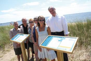
KNOWING WHERE TO PADDLE: Buckeye Brook Coalition members and Mayor Scott Avedisian admire the new paddle maps located at Conimicut Point Park. From left: Bill Aldrich, Phil D’Ecrole, Carmen D’Ecrole, Lori Earnshaw and foreground: Stephanie Van Patten and Mayor Scott Avedisian.
For those looking to spend time canoeing or kayaking near Conimicut Point, the Buckeye Brook Coalition and the Rhode Island Foundation have made navigating Narragansett Bay easier by creating two new paddling maps.
The maps contain everything from basic information, such as estimated time of travel and level of difficulty, to historical facts and information about local wildlife.
Vice President of the Buckeye Brook Coalition George Shuster said the main goals of the maps are to advertise Warwick’s great coastline and make the area into a well-known kayaking and canoeing destination.
“We wanted to put them at places where we think there’s a lot of people who will see them who don’t kayak to encourage them to kayak,” said Shuster. “Those are the main people we want to reach.”
The Buckeye Brook Coalition created the maps in partnership with the Rhode Island Blueways Alliance. The Rhode Island Foundation funded the project with a $15,000 grant to the Narragansett Bay Estuary Program and the R.I. Blueways Alliance. The grant allowed 10 Rhode Island Watershed groups to create paddle maps. So far, the Buckeye Brook Coalition is the only group to have finalized maps.
The standing maps, whose frames were made and installed by city workers, are located at the entryway to the beach behind the Conimicut Point Park playground. Not only are they located there to draw interest from people visiting the playground but also due to its proximity to the lifeguards.
“It’s good that they’re close to the lifeguards so we can see what’s happening to them,” said Mayor Scott Avedisian. “One of the worst things is when you do something like this and then it disappears in two weeks.”
According to volunteer Stephanie Van Patten, Shuster’s wife, the standing maps at Conimicut Point are not the only way the Buckeye Brook Coalition is hoping to draw interest to the area.
“We hope to have handouts of the maps at outdoor sports stores such as Eastern Mountain Sports and REI,” said Van Patten. “They have similar maps for hiking and the stores could recommend where’s a good spot to put in, where to go, and what level they need for the paddle and hopefully, bring more people to the area.”
Avedisian said that he believes the maps will be very beneficial to the area and is thankful to the Buckeye Brook Coalition. “They provide useful information for people looking for ways to access recreation facilities in the city and they bring good exposure to the Buckeye Brook Coalition and the watershed,” said Avedisian. “My thanks to these community volunteers for their efforts.”
The coalition aims to have displays at other locations.
“We’re hoping to have them at Rocky Point near the beach, the Longmeadow Fishing Area at the east end of Samuel Gorton Avenue, and West Shore Road at Buckeye Brook just north of the intersection of West Shore Road and Church Avenue,” said Schuster.
The Coalition would like to take the project a step farther next summer.
“ One way to promote kayaking at Conimicut Point is to have a kayak rack where people can come and rent them for one, two, or three hours at a time,” said Van Patten. “There would be a fee and a person at the park would provide you with a life vest, kayak and paddle. This way, if you don’t have your own kayak or you want to try it for the first time, you can get out and kayak and not have to buy one.”
Shuster got the idea for putting paddle maps at Conimicut Point Park after he went paddling with coalition President Paul Earnshaw.
“There were so many interesting things along the way that I thought it would be a great idea to put it all on a map and show what was there and where to paddle,” said Shuster.
According to Shuster, deciding what would be on the maps was easy.
“For this area, there are two components of what make it interesting; its natural history, the plants and animals you see along the way, and the human history,” said Shuster. “We really wanted to mix these two elements and show the layers of history along the route.”
One of the main points of history mentioned on the maps is the Native American history of the area.
“Along this paddle, the Native American Indians had a summer encampment and people have found arrowheads both in the brook and along the shoreline in that area,” said Shuster.
Those who want to learn more about the project or take the maps with them during their kayaking or canoeing trips should visit the Buckeye Brook Coalition website. The maps can be printed out online from www.buckeyebrook.org.